About Waterlands
Ongoing, climatic and land use and land cover (LULC) change are two major factors producing important changes on hydrological processes, which will likely produce further detrimental impact on water issues to large sectors of the global population. How we mitigate against and adapt to water security threats in the context of global change will play a key role in domestic and international politics for the next decades (Black et al., 2010).
WATERLANDS seek for different concepts related to water responses to land cover dynamics and climate change:
New challenges for Integrated Catchment Management
Nature based solutions and Blue-Green Infrastructure Networks for climate change adaptation
In response to the current consequences of global change and to halt the current biodiversity loss and associated provisioning of relevant ecosystem services, the European Union adopted the Biodiversity Strategy in May 2011. This strategy is built around six mutually supportive targets, one of which represents the first normative reference related to Green Infrastructure Networks: “by 2020, ecosystems and their services should be maintained and enhanced by establishing green infrastructure and restoring at least 15% of degraded ecosystems”. Responding to this political ambition the European Commission published a new strategy in May 2013 to promote the use of Blue and Green Infrastructure networks (BGIN) across Europe. The strategy aims to create a robust framework in order to promote and facilitate BGIN implementation within existing legal, policy and financial instruments.
A BGIN can be broadly defined as “a strategically planned network of high quality natural and semi-natural ecosystems/habitats that is designed and managed to deliver a wide range of ecosystem services and to protect biodiversity in both rural and urban settings” (Own definition see HERE).
Many barriers emerge when specific nature based solutions are considered for real implementation. In this regard, the main challenges that ICM and Landscape Planning face today for a broader application of these techniques are related to:
(1) The need for evidence-based knowledge on the design and efficiency of nature based solutions.
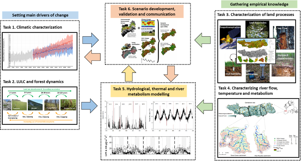
(2) The need to develop integrated modelling approaches accounting for the main drivers of change.
(3) Building credible future scenarios in which a range of solutions could be evaluated.
(4) Inter-administrative cooperation and a change on the management culture towards more participative learning approaches.
The relationships between land cover (forests) dynamics and water (rivers)
Recent studies (e.g. Belmar et al., 2018) and extensive and updated reviews on forest-water relationships (Creed and van Noordwijk, 2018), have pointed to the need of addressing the role of different types of forests, of land cover dynamics and of secondary succession processes on forests (Figure). The differential responses that water amount and temperature might have to changes on land cover or forests of different age or between natural forest and tree plantations are related to a whole array of characteristics that affect key hydrological processes and microclimatic conditions. In relation to strict water-forest relationships, important changes on water fluxes have been identified theoretically on a forest maturation gradient (Chapin III et al., 2002) and on empirical studies (Vertessy et al., 1998).
Figure. Evolution of fluxes or pools of Carbon-Water from Gross Primary Production (GPP), Biomass-water storage in soils or plants and Net Primary Production (NPP) and Evapotranspiration along the lifetime of a natural forest plot (A; Adapted from Chapin III et al., 2002).
The uncertainty of global-change scenarios for forest-river relationships
Climate change predictions are nowadays available for many parts of the world accounting mainly for precipitation and air temperature in a set of different scenarios (e.g., Collins et al., 2013), however, global LULC scenarios are still lagging far behind. The main reason for this is that land cover dynamics are generated by changes on land uses, which are mainly related to macro-economic drivers, but with a high dependence on local socio-economic ones (e.g., population, wealth, consumption preferences, agricultural productivity, land-use regulation, and trade; Stehfest et al., 2019). In this regard, different land cover transitions might emerge from land abandonment or land use intensification depending on the natural and socioeconomic environment in which these changes occur (Figure).
Figure. Land Use and Land Cover transitions on the Cantabrian Cordillera generated by human abandonment of traditional practices (green arrow) or by a more intensification of the landscape (orange arrow). Tree plantations could be developed from any of the other land cover types except for denuded land, and are very rarely restored to natural conditions
WATERLANDS aims at investigating which are the main differences on certain attributes among land cover (pastures, shrubs and forest) and forest (young forests, mature forests and tree plantations) types that modulate the effect they have on stream flow and water temperature, so as to have those differences into account when generating future scenarios of global change for water resource management.

