Working plan
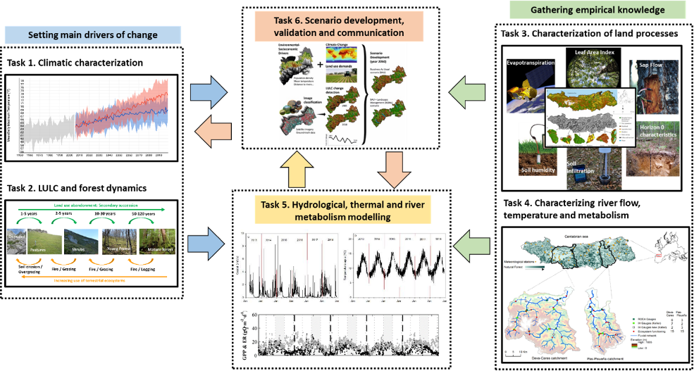
WATERLANDS will be developed under 6 major tasks that are related to each other in a specific way to maximise the outreach of the project results (Figure). Tasks 1 and 2 develop the main framework in which current and future scenarios will be developed, while task 6 will help defining local tailored scenarios of change. Task 3 and 4 will generate new empirical knowledge that will help increase our understanding on how land cover and forest characteristics shape water and thermal responses in rivers. Task 5 will develop and integrate hydrological, thermal and metabolism models to be able to generate results under the different scenarios, which will be validated and disseminated within Task 6.
Task 1. Climatic characterisation
The main aim of this task it to characterise the current, past and future spatial climatic patterns. This task will thus consist in generating a database with the climatological data for present climate (1990-2020) and scenarios of climate change up to 60 years into the future (2050-2080), at 1km x 1km spatial resolution, using available data from Spanish Meteorology Agency (AEMET) and Universidad de Cantabria.
Subtask 1.1. Present climate
Subtask 1.2: Scenarios of climate change
Task 2. LULC and forest dynamics
Similarly to Task 1, this task main objective is to characterise the current, past and future spatial patterns of different land cover and forest types in the studied region. This task will be mainly accomplished through the use of remote sensing and spatial modelling techniques.
Subtask 2.1. LULC and forest characterisation
Subtask 2.2. LULC and forest scenarios
Task 3. Characterisation of land processes
This task aims at characterising key land cover and forest processes that influence hydrological and thermal regimens in rivers. Subtask 3.1. will be developed for the whole area of the project, as it is mainly related to satellite information and wide spatial areas could be covered, while subtasks 3.2 and 3.3. will only be developed in 18 plots where the 6 dominant land cover and forest types of interest dominate (i.e., pasture, shrubs, young forest, oak and beech mature forests and tree plantations; Figure).
Figure Map of the study region showing actual LULC landscape and a selection of 18 plots (3 replicates x 6 types) in which the selected land cover and forest types (Meadows, Shrubs, Young forest, Mature forest-Oak, Mature forest-Beech, Tree-plantation) dominate.
Subtask 3.1. Estimating evapotranspiration
Subtask 3.2. Monitoring land hydrological characteristics
Subtask 3.3. Deployment of temperature sensors.
Task 4. Characterising river flow, temperature and metabolism
This task aims at characterising the hydrological, thermal and metabolism regimes of two river networks with highly contrasting LULC patterns but with a very similar climate (Belmar et al., 2018). The information gathered in this task will be further used to assess the effects that LULC and forest types might produce on these regimes (Task 6). We have selected the Pas-Pisueña and the Deva-Cares catchments because they represent two extremes on a LULC gradient (Figure).
Figure Natural forest distribution and meteorological stations available in the Cantabric catchments. The distribution of river flow gauges maintained by the Cantabric Water Agency (Confederación Hidrográfica del Cantábrico) and from the IHCantabria in the two selected catchments (Deva-Cares: 1100 km2 and Pas Pisueña: 650 km2) are also shown along with the 15 river reaches in which we will monitor water temperature and river metabolism.
Subtask 4.1. Monitoring river flow
Subtask 4.2. Monitoring river metabolism and temperature
Task 5. Hydrological, thermal and river metabolism modelling
This task aims at developing models for hydrological, water temperature and river metabolism that could later be used and integrated in the different scenarios of global change.
Subtask 5.1. Distributed hydrological model
Subtask 5.2. Thermal modelling
Subtask 5.3. River metabolism model
Task 6. Scenario development, validation and communication
The main objective of this final task is to maximise the dissemination of the project results to all relevant parties interested on the project developments.
Subtask 6.1. Validation of models and scenarios
Subtask 6.2. Transfer and dissemination of results

